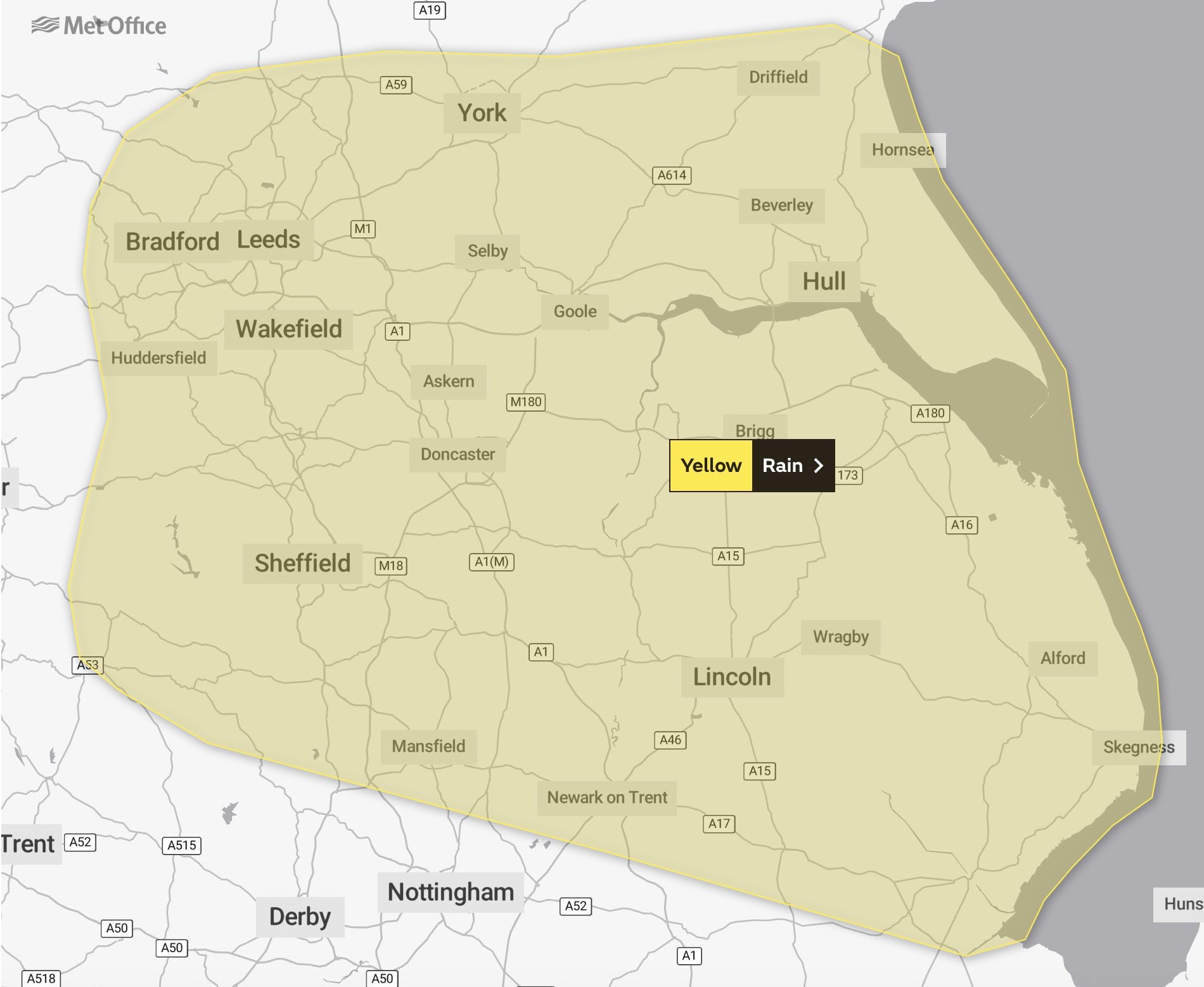
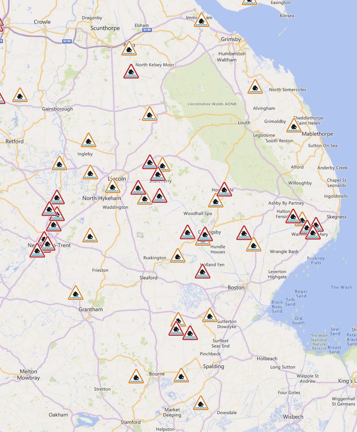
As of midday on Wednesday, October 25, 36 roads in Lincolnshire remain closed due to flooding during and after Storm Babet on Friday, October 20, and Saturday, October 21.

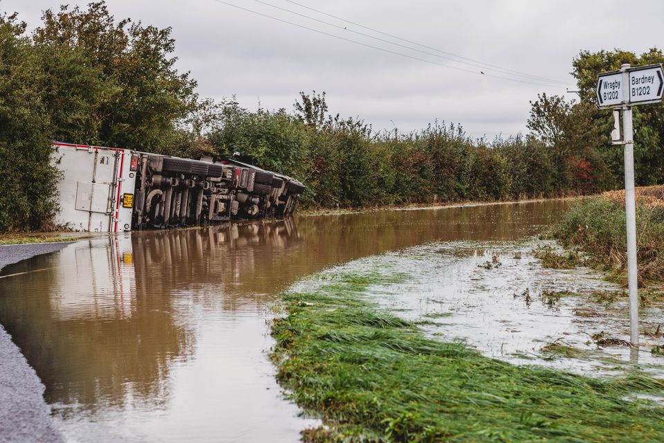
The advice from officials: Please do not drive through flood water. Lincolnshire Fire and Rescue has dealt with 14 incidents of vehicles becoming trapped after driving through floods — you do not want to be next.

  • Waterloo Lane, Skellingthorpe
  • B1399 Lincoln Road, Fulnetby
  • Barff Lane, Glentham
  • B1205 Gainsborough Road Northorpe near Scotter
  • Long Leys Road, Lincoln
  • Main Road, Aby
  • Roughton Road, Kirkby on Bain
  • Main Street, Kirkby on Bain
  • Moor Lane, Horsington
  • Beck Street, Digby
  • Billingborough Road, Folkingham
  • Heath Lane, Great Ponton
  • Main Road, Little Hale
  • Westborough Lane, Long Benington
  • School Lane, Sedgbrook
  • High Street, North Scarle
  • Chapel Lane, North Scarle
  • School Lane, North Scarle
  • Eagle Road, North Scarle
  • Church Lane, North Scarle
  • Claypool Lane, Scothern
  • Fen Lane, Dunston
  • Moor Lane, Potterhanworth
  • Croft Lane at Low Road Junction, Burgh
  • Fen Road, Mareham Le Fen
  • Duckpool Lane, Stixwould
  • Waterside South, Lincoln
  • Waterside North, Lincoln
  • Beckingham Road, Stapleford
  • West Bank, Saxilby
  • Balmoral Avenue, Spalding
  • Main Road, Low Toynton
  • Ferry Road, Short Ferry
  • Nelthorpe Street, Lincoln
  • Napier Street, Lincoln
  • Sibthorp Street, Lincoln

Some previous closures have been lifted where the routes are now passable with care. With the situation changing so fast, there may well be roads reopened before we hear about them. If you see closure signs being lifted by council officers, or the police, please still take great care getting about.

More updates and coverage is now provided on MyLocal.co.uk

More rain is expected across Lincolnshire on Tuesday, with the Met Office warning that it may lead to further flooding, as waterways and the ground are waterlogged in the aftermath of Storm Babet over the weekend.

The whole of Lincolnshire is covered by the Met Office warning, alongside parts of Humberside, Nottinghamshire, and South Yorkshire, with rain expected throughout Tuesday.

The flood alerts map on Tuesday afternoon.

The Environment Agency also has in place dozens of flood warnings and alerts across our region, covering a lot of the areas affected last weekend, including Lincoln, Short Ferry, Ruskington, Wainfleet and Horncastle. See the flood alerts map here.

A range of roads across Lincolnshire remain closed due to flooding, with the advice remaining not to drive through flood water.

  • Waterloo Lane, Skellingthorpe
  • B1399 Lincoln Road, Fulnetby
  • Barff Lane, Glentham
  • B1399/A158, Bullington
  • B1205 Gainsborough Road Northorpe near Scotter
  • Long Leys Road, Lincoln
  • B1198 Great Steeping
  • Main Road, Aby
  • Roughton Road, Kirkby on Bain
  • Main Street, Kirkby on Bain
  • Moor Lane, Horsington
  • Beck Street, Digby
  • Billingborough Road, Folkingham
  • Heath Lane, Great Ponton
  • Main Road, Little Hale
  • Westborough Lane, Long Benington
  • School Lane, Sedgbrook
  • High Street, North Scarle
  • Chapel Lane, North Scarle
  • School Lane, North Scarle
  • Eagle Road, North Scarle
  • Church Lane, North Scarle
  • Claypool Lane, Scothern
  • Scothern Road, Langworth
  • Fen Lane, Dunston
  • Moor Lane, Potterhanworth
  • Croft Lane at Low Road Junction, Burgh
  • Fen Road, Mareham Le Fen
  • Duckpool Lane, Stixwould
  • Waterside South, Lincoln
  • Waterside North, Lincoln
  • Beckingham Road, Stapleford
  • West Bank, Saxilby
  • Balmoral Avenue, Spalding
  • Main Road, Low Toynton
  • Ferry Road, Short Ferry

More updates and advice if you’ve been impacted by flooding is available on the Lincolnshire County Council website.

STAY UPDATED: Please make sure you download the MyLocal Lincolnshire app and regularly check our new website MyLocal.co.uk

+ More stories