April 19, 2022 7.30 pm
This story is over 37 months old
Lincoln volunteer geolocating harrowing Ukraine war zone images
He has also analysed World War II images
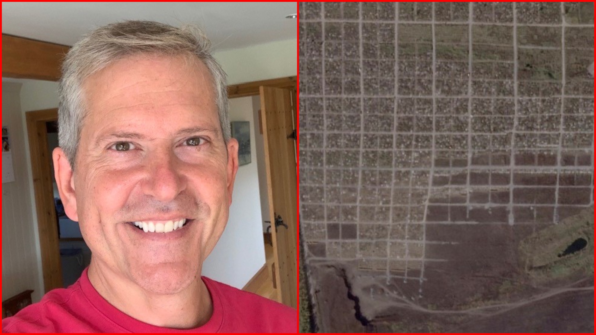
Andy Shaw (left) is helping to geolocate and document images of possible war crimes in Ukraine, including from a local cemetery in Starokrymske (right). Image: Planet Labs PBC
Families being burnt alive in a cellar and bodies being exhumed are just some of the thousands of harrowing images being analysed by volunteers, including a man living in Lincoln who is determined to bring justice against those causing Russia’s invasion of Ukraine.
Andy Shaw works as a finance director for a Lincoln-based company, and over the past two years he has also been a part-time volunteer for the International Bomber Command Centre Digital Archive in Lincoln.
The 53-year-old has been identifying and geolocating uncaptioned aerial photographs from the Second World War. After realising he had a flair for the work, he is now using those skills to help Open Source Intelligence (OSINT) organisation – Centre for Information Resilience – geolocate and document images of possible war crimes in Ukraine.
Andy is one of many volunteers working to geolocate, verify and document thousands of images from the war zone in Ukraine. The project started in February 2022 and will carry on for a long time as “there is still a lot of images and data to sift through”, Andy said.
When asked if he believes he has evidence of war crimes, Andy told The Lincolnite: “Yes, undoubtedly. It is difficult to say as it needs verifying legally, but the sort of images we are getting including bullet holes in the head, hands tied behind their backs, evidence of cluster munitions, and they support the war crime notion.
“There are also images of destroyed towns and burnt bodies which is very graphic, bodies being exhumed, and families being burnt alive in a cellar.
“The organisations like Centre for Information Resilience provide training to deal with graphic images and are aware it can impact mental health. Personally it can be quite distressing, but it makes me more determined to follow through on what I’m doing to try and help get justice.
“The Open Source will be shared with government agencies (once the work is complete), as well as to anybody who legitimately requests it such as journalists.
“It is one piece of the overall jigsaw. Verification of these types of images can be essential and may be used to support criminal cases in the future.”
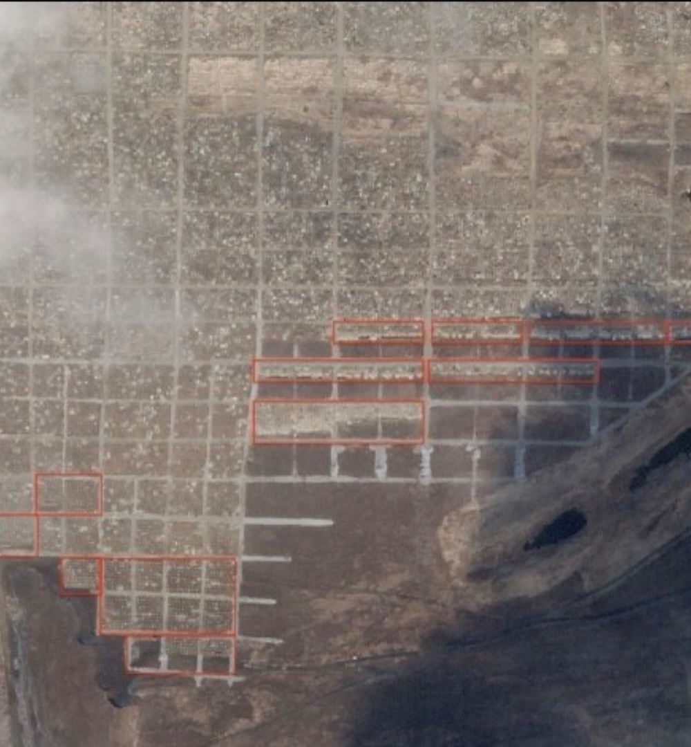
Starokrymske cemetery on March 9, 2022, with mark ups. | Image: Planet Labs PBC
Andy now has access to free satellite imagery of Ukraine provided by commercial organisations which is updated daily. Volunteers need to verify an event on the ground that is possibly captured in a short video clip or a photo taken by a bystander’s smartphone.
To do this, the satellite image of the area is studied, and any distinctive buildings identified. Once the location is verified, the grid reference and summary of the image is entered into a database. The image is also graded in terms of ‘violence’ and how graphic the image might be.
The volunteers like Andy make sure videos and images are tied to the location they purport to have been taken, including through Google Earth and getting the exact co-ordinates, but “in a way that won’t compromise the person who took the photo or video”.
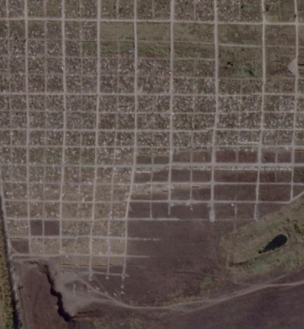
Satellite imagery has been extremely useful identifying possible sites of mass graves. Recently, Andy was asked to study satellite imagery from a cemetery in Starokrymske and count the new graves dug between different dates.
This is to provide “yet more evidence to underpin the fact that there are civilian massacres taking place in Ukraine”.
He said in the south west corner of the cemetery, there are around 720 new graves during the period from October 10, 2021 and March 9, 2022, excluding the new areas, which unfortunately would add hundreds more.
Starokrymske cemetery on October 10, 2021. | Image: Planet Labs PBC
Andy told The Lincolnite that in many cases the images are “horrific” and the verification of the image and its geolocation, combined with metadata, from the bystanders’ smartphones are “an irrefutable way of documenting potential war crimes”.
A powerful example is the recent events in the Ukrainian city of Bucha, a city in Ukraine, and volunteers have “seen the images of civilians who were apparently killed in cold blood on the streets, many with their hands tied behind their backs”.
They studied satellite images of Bucha in the weeks during the Russian occupation of the town. Andy said: “The bodies are clearly visible in the images and the volunteers were then able to match video footage taken on the ground with the precise location of the bodies in the satellite imagery.”
Centre for Information Resilience recently highlighted the importance of its work with an example of a geolocated video of a decapitated woman in a car, showing how it was geolocated.
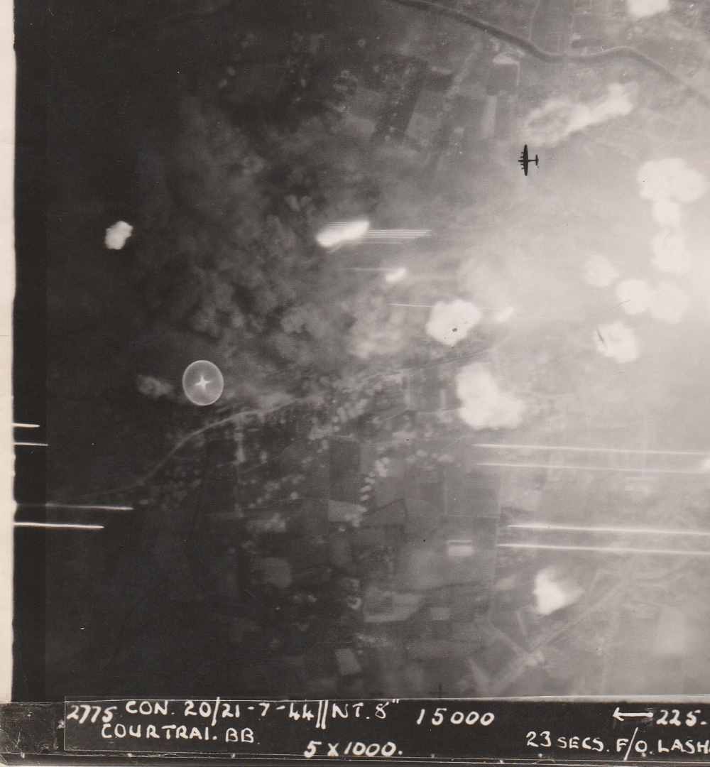
World War II archive images project
Photo taken by the crew of P Wilson on the night of July 20/21, 1944. Image: IBCC Digital Archive/University of Lincoln
Around two years ago the IBCC put Andy in touch with Alex Pesaro, a digital archivist and module leader for cultural and heritage attractions management at the University of Lincoln. Alex introduced Andy to the ‘Digital Archive’ project being overseen by the University of Lincoln on behalf of the IBCC
When working on the project of uncaptioned Second World War images, Andy initially spent his time producing written summaries of recordings of interviews with veterans before he was asked to also try geolocation.
Andy, whose father and grandfather were both pilots in the RAF, said: “There is a sense of satisfaction when an aerial photo is successfully geolocated. However, I am always mindful as I analyse these images from the comfort of my sofa, I never forget that these images were taken over 75 years ago by a young bomber crew in mortal danger, whose chances of surviving a tour in Bomber Command were slim. It is a privilege that I can play a small part in preserving that image, that “moment in time”, for future generations in the Digital Archive.”
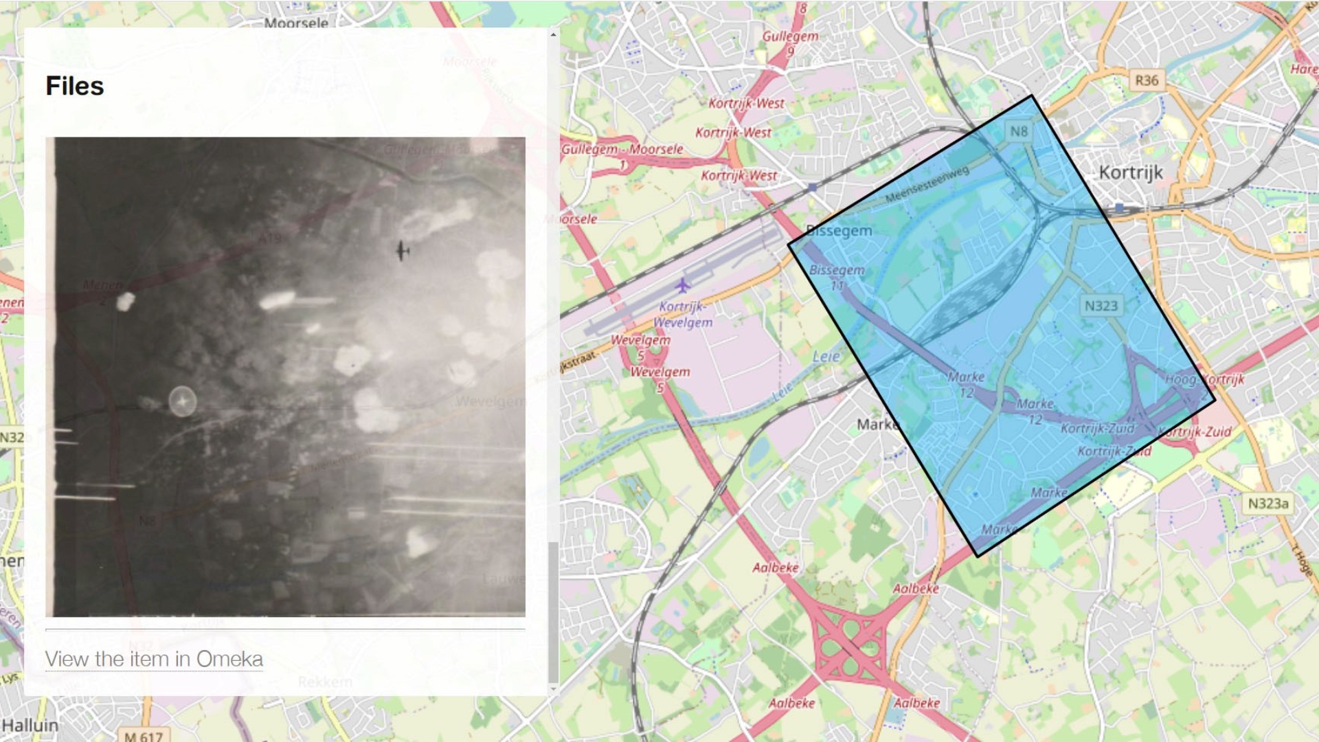
Extract from the IBCC Digital Archive Map: Courtrai in 1944 and present day. Image: IBCC Digital Archive/University of Lincoln
Digital archivist Alex Pesaro said: “We strongly recommend volunteers to use desktop PCs with big high-resolution monitors. When Andy told me the he was going to use a smartphone, I was sceptical at first.
“To my utter surprise, what he produced has been of the highest possible standard. He was able to pick up almost invisible features and to match them with a high degree of confidence; on top of that, Andy was quickly able to solve problems that have resisted multiple attempts by different volunteers and staff.
“When I demonstrate the way archive items can be accessed from a map, users in the UK and abroad are always highly appreciative. This compares favourably with other archives that rely on traditional keyword search.”
The Lincolnite welcomes your views. All comments are reactively-moderated and must obey the house rules. Please stay on topic and be respectful of other readers.
Exciting news for MyLocal app users and The Lincolnite readers! Our latest update is now available to download from your app store and comes packed with the best local news experience you can enjoy.
Revamped News Feed: Enjoy faster loading times and smoother scrolling that make catching up on local news a breeze.
New Play Video Feed: Dive into a dynamic video feed that brings local stories to life in a whole new way.
Enhanced In-App Browser: Access external links quickly and efficiently, right from the app, without any distractions.
Update your MyLocal app from your app store (version 2.73) now and start enjoying these great new features today!
P.S.: Start your MyLocal membership today to support MyLocal and The Lincolnite deliver you a better local news experience and honest journalism from across Lincolnshire.
P.P.S.: We have some huge things in the pipeline, stay tuned!
 Whatsapp